The Walk Route
Here you will find the full details of the walk route including the maps for each day of the event and information on places you can come and cheer me on and show your support.
Day 1
Starting at 8am by the Essex Records Office along the River Chelmer, the walk follows the River Chelmer to it's conclusion at The Old Ship pub in Heybridge and returns along the same route. The total distance covered is 41.5km (25.8 miles).
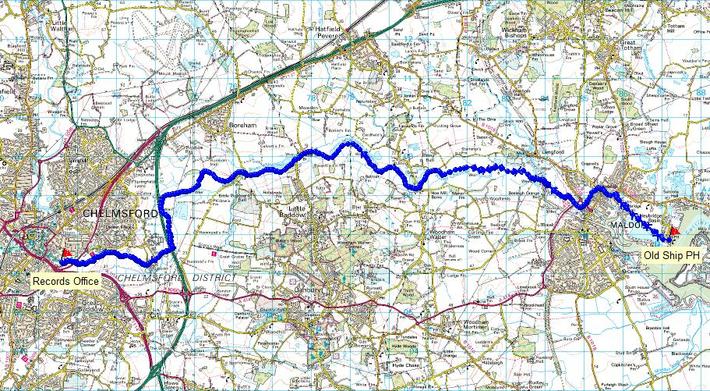
Kelly will be stopping at Papermill Lock both on the way to, and on the return journey from, Heybridge. She will also be stopping at The Old Ship pub in Heybridge. These are areas with nearby public car parking where people can come and show their support and meet Kelly during her walk.
Day 2
The second day of the challenge will start at 8am from Galleywood Common, next to St Michaels & All Angels Church, travelling north and concluding at Great Notley Park in Braintree.
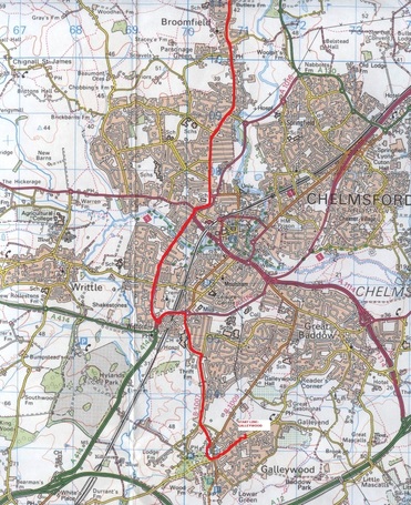
From St Michaels & All Angels Church, the route will go north along the B1007 (Stock Road), past the Running Mare and Fox & Hounds pubs, to the Miami Roundabout. Left turn over the bridge and then right at the next roundabout to pick up Waterhouse Lane. Follow Waterhouse Lane to the junction with Parkway. Continue along Parkway before joining the B1008 (Broomfield Road), past The Angel public house, The Kings Arms and Broomfield Hospital.
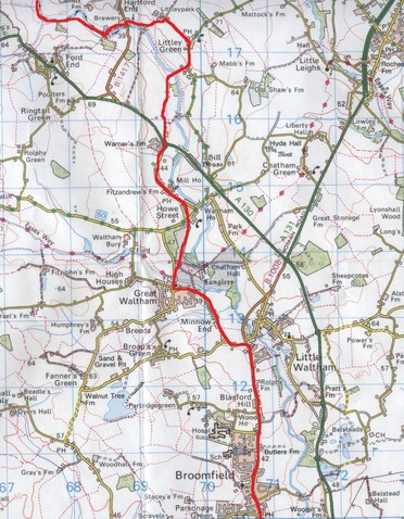
Turn right into Chelmsford Road towards Great Waltham. Continue into Great Waltham and past The Beehive public house, turning right towards Howe Street. Bear right onto a public footpath emerging near Parsonage Lane in Howe Street. Follow the main road north past The Green Man pub to the junction with A130 (Essex Regiment Way). Go directly across the roundabout along a narrow bridleway road towards Littley Green. Turn left at the end of the bridleway and into Littley Green village, to The Compasses Inn for a check point stop.
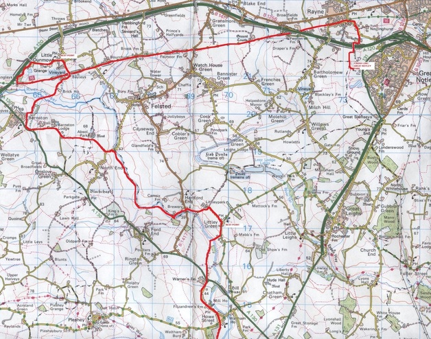
From The Compasses Inn, head South until the road junction signposted Hartford End, Felsted and turn right. At the road junction continue straight on past Ridleys Brewery along Mill Lane. At the end of the road pick up the public footpath following the River Chelmer north east. Branch off of the footpath near Ford End and follow as small country lane to it's junction with Parsons Lane in Barnston. Turn left onto Parsons Lane and follow it to it's junction with the A130 (Chelmsford Road). Turn left along the A130 through Barnston and then turn left onto a small country lane heading north east towards the River Chelmer. Cross the River and continue along the footpath to Little Dunmow. Emerge from the footpath onto Brooke Street and head north.
Check point stop at The Flitch of Bacon, in Little Dunmow. From The Flitch of Bacon, head west along Grange Lane to pick up The Flitch Way.
Follow the Flitch Way east to Rayne. Turn off the Flitch Way just after Rayne Station and turn down Fairy Hall Lane towards Great Notley Park. Finish at Great Notley Park, Braintree.
Total distance for day 2 of the walk is 42km (26.2 miles).
